CAMx高空排放檔之網格化
背景
高空點源排放檔案沒有適用的顯示軟體。須轉成其他格式,此處以d04範圍地面排放量檔案格式為目標,該格式可以在VERDI或MeteoInfo中開啟。
程式說明
程式執行
- pt2em_d04.py只需要一個引數,就是CAMx點源排放量檔案。
- 程式會以
template_d4.nc為模版,將點源排放量予以網格化填入模版相對應位置。 - 時間標籤則與輸入檔案一致。
pt2em_d04.py fortBE.413_teds10.ptsE01.nc
- 執行結果檔案會再輸入檔名稱後加上
_d04.nc,以標示其網格系統特性。
程式分段說明
- 調用模組
#kuang@node03 /nas1/TEDS/teds11/ptse
#$ cat -n pt2em_d04.py
     1  import netCDF4
     2  import numpy as np
     3  import datetime
     4  import os, sys, subprocess
     5  from pandas import *
     6
- 重要相依性
- 取得
ncks、ncatted等程式之位置 - 取得引數(高空點源檔案名稱)
- 取得
     7  ncks=subprocess.check_output('which ncks',shell=True).decode('utf8').strip('\n')
     8  ncatted=subprocess.check_output('which ncatted',shell=True).decode('utf8').strip('\n')
     9  MM=sys.argv[1]
    10  fname=MM
- 讀取高空排放量檔案(內設為CAMx 7版本)
- 變數讀取是最花時間的步驟
    11  #store the point source matrix
    12  nct = netCDF4.Dataset(fname,'r')
    13  Vt=[list(filter(lambda x:nct.variables[x].ndim==j, [i for i in nct.variables])) for j in [1,2,3,4]]
    14  ntt,nvt,dt=nct.variables[Vt[2][0]].shape
    15  try:
    16    nopts=nct.NOPTS
    17  except:
    18    nopts=nct.dimensions['COL'].size
    19
    20  TFLAG=nct.variables['TFLAG'][:,0,:]
    21  ETFLAG=nct.variables['ETFLAG'][:,0,:]
    22  SDATE=nct.SDATE
    23  STIME=nct.STIME
    24  Vt1=[i for i in Vt[1] if i not in ['CP_NO','plumerise']]
    25  var=np.zeros(shape=(len(Vt1),ntt,nopts))
    26  for v in Vt1:
    27    iv=Vt1.index(v)
    28    var[iv,:,:]=nct.variables[v][:,:]
    29
- 開啟模版,並讀取網格系統之設定內容,用以計算網格位置標籤。
    30  fname=MM+'_d04.nc'
    31  os.system('cp template_d4.nc '+fname)
    32  nc = netCDF4.Dataset(fname,'r+')
    33  V=[list(filter(lambda x:nc.variables[x].ndim==j, [i for i in nc.variables])) for j in [1,2,3,4]]
    34  nt,nlay,nrow,ncol=nc.variables[V[3][0]].shape
    35  #determination of camx version and prepare IX/IY
    36  ver=7
    37  if 'XSTK' in Vt[0]:ver=6
    38  X={6:'XSTK',7:'xcoord'}
    39  Y={6:'YSTK',7:'ycoord'}
    40  #store the coordinate system param. for calibration
    41  for c in ['X','Y']:
    42    for d in ['ORIG','CELL']:
    43      exec(c+d+'=nc.'+c+d)
- 計算每根煙道的網格位置標籤(
IX,IY)備用
    44  IX=np.array([(i-nc.XORIG)/nc.XCELL for i in nct.variables[X[ver]][:nopts]],dtype=int)
    45  IY=np.array([(i-nc.YORIG)/nc.XCELL for i in nct.variables[Y[ver]][:nopts]],dtype=int)
    46  nct.close()
    47  nc.close()
    48
- 篩選非為0的內容來輸出
- 如果確實有部分變數沒有內容,則從模版中予以去除,以減少檔案容量
    49  #variable sets interception and with values
    50  sint=[v for v in set(Vt1)&set(V[3]) if np.sum(var[Vt1.index(v),:,:])!=0.]
    51  if len(sint)!=len(V[3]):
    52    s=''.join([c+',' for c in set(V[3])-set(sint)])
    53    ftmp=fname+'tmp'
    54    res=os.system(ncks+' -O -x -v'+s.strip(',')+' '+fname+' '+ftmp)
    55    if res!=0: sys.exit(ncks+' -x var fail')
    56    ns=str(len(sint)-1)
    57    res=os.system(ncks+' -O -d VAR,0,'+ns+' '+ftmp+' '+fname)
    58    if res!=0: sys.exit(ncks+' -d VAR fail')
    59  #template is OK
    60
- 執行
pandas.pivot_table,以利用其平行處理功能。- 須將矩陣轉為資料表
    61  #pivoting
    62  ntm,NREC=ntt,nopts
    63  sdt,ix,iy=(np.zeros(shape=(ntm*NREC),dtype=int) for i in range(3))
    64  idatetime=np.array([i for i in range(ntt)],dtype=int)
    65  for t in range(ntm):
    66      t1,t2=t*NREC,(t+1)*NREC
    67      ix[t1:t2]=IX
    68      iy[t1:t2]=IY
    69  for t in range(ntm):
    70      t1,t2=t*NREC,(t+1)*NREC
    71      sdt[t1:t2]=idatetime[t]
    72  dfT=DataFrame({'YJH':sdt,'IX':ix,'IY':iy})
    73  for v in sint:
    74    iv=Vt1.index(v)
    75    dfT[v]=var[iv,:,:].flatten()
    76  pv=pivot_table(dfT,index=['YJH','IX','IY'],values=sint,aggfunc=sum).reset_index()
- 再將
pivot_table結果轉成矩陣輸出- 注意nc檔案並不適用np.array的fancy indexing,詳NC檔案多維度批次篩選
    77  pv.IX=[int(i) for i in pv.IX]
    78  pv.IY=[int(i) for i in pv.IY]
    79  pv.YJH=[int(i) for i in pv.YJH]
    80  boo=(pv.IX>=0) & (pv.IY>=0) & (pv.IX<ncol) & (pv.IY<nrow)
    81  pv=pv.loc[boo].reset_index(drop=True)
    82  imn,jmn=min(pv.IX),min(pv.IY)
    83  imx,jmx=max(max(pv.IX)+abs(imn)*2+1,ncol), max(max(pv.IY)+abs(jmn)*2+1,nrow)
    84  if imn<0 and imx+imn<ncol:sys.exit('negative indexing error in i')
    85  if jmn<0 and jmx+jmn<nrow:sys.exit('negative indexing error in j')
    86  idx=pv.index
    87  idt=np.array(pv.loc[idx,'YJH'])
    88  iy=np.array(pv.loc[idx,'IY'])
    89  ix=np.array(pv.loc[idx,'IX'])
    90  #reopen nc files and write time flags, and lengthen the span of time
    91  nc = netCDF4.Dataset(fname,'r+')
    92  for t in range(ntt):
    93    for i in range(2):
    94      nc.variables['TFLAG'][t,:,i]=TFLAG[t,i]
    95      nc.variables['ETFLAG'][t,:,i]=ETFLAG[t,i]
    96  nc.SDATE=SDATE
    97  nc.STIME=STIME
    98  #blanking all variables
    99  for c in sint:
   100    nc.variables[c][:]=0.
   101    z=np.zeros(shape=(ntm,jmx,imx))
   102    ss=np.array(pv.loc[idx,c])
   103    #Note that negative indices are not bothersome and are only at the end of the axis.
   104    z[idt,iy,ix]=ss
   105  #also mapping whole matrix, NOT by parts
   106    nc.variables[c][:,0,:,:]=z[:,:nrow,:ncol]
   107  nc.close()
- 座標微調
- 這一段是早期使用twd97座標系統套用VERDI(內政部縣市
shape檔)時的誤差,改用經緯度後已無需要執行。
- 這一段是早期使用twd97座標系統套用VERDI(內政部縣市
   108  #using CSC and XieHePP to calibrate the Map
   109  xiheIXY_Verdi=(67,126) #fallen in the sea
   110  xiheIXY_Target=(66,124)#calibrate with County border and seashore line
   111  CSCIXY_Verdi=(20,30) #fallen in the KSHarbor
   112  CSCIXY_Target=(21,31)
   113  rateXY=np.array([(xiheIXY_Target[i]-CSCIXY_Target[i])/(xiheIXY_Verdi[i]-CSCIXY_Verdi[i]) for i in range(2)])
   114  dxy_new=rateXY*np.array([XCELL,YCELL])
   115  oxy_new=(1-rateXY)*dxy_new*np.array([ncol,nrow])/2.+np.array([XORIG,YORIG])
   116  cmd1=' -a XCELL,global,o,f,'+str(dxy_new[0])
   117  cmd2=' -a YCELL,global,o,f,'+str(dxy_new[1])
   118  cmd3=' -a XORIG,global,o,f,'+str(oxy_new[0])
   119  cmd4=' -a YORIG,global,o,f,'+str(oxy_new[1])
   120  #ncatted -a XCELL,global,o,f,2872.340425531915 -a YCELL,global,o,f,2906.25 -a XORIG,global,o,f,-119074.46808510639 -a YORIG,global,o,f,-199078.125 fortBE.413_teds10.ptsE01.nc_d04.nc
   121  #res=os.system(ncatted+cmd1+cmd2+cmd3+cmd4+' '+fname)
   122  #if res!=0:sys.exit('fail ncatted')
   123  sys.exit('fine!')
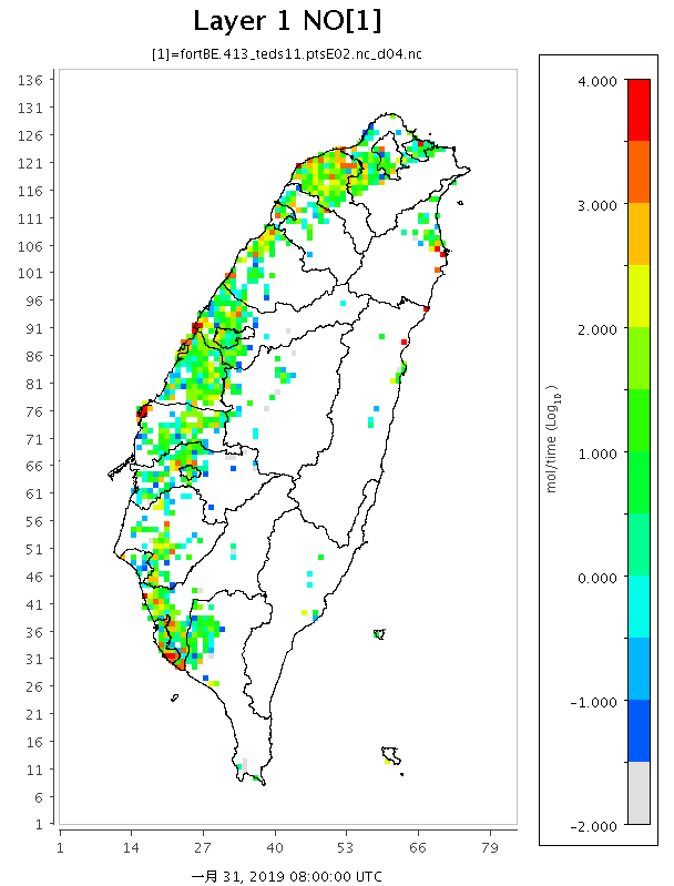
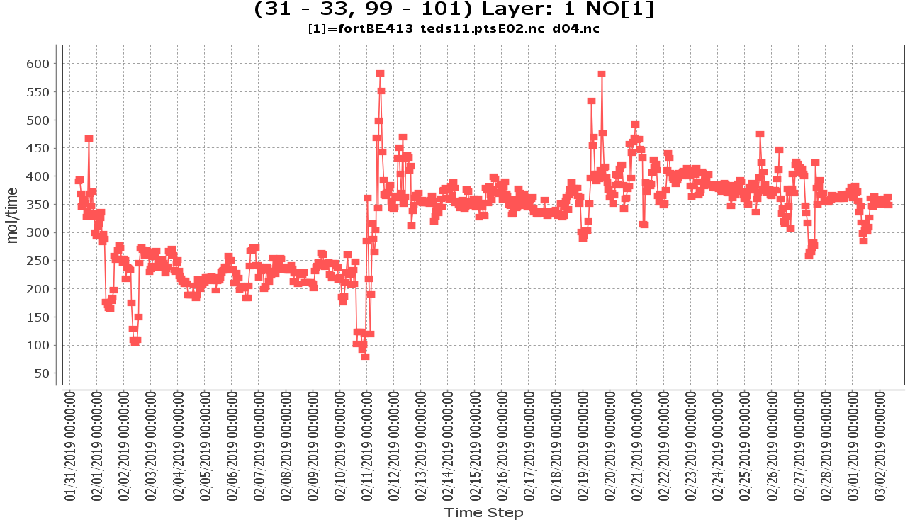
結果檢視
Reference
- lizadams, Visualization Environment for Rich Data Interpretation (VERDI): User’s Manual, github, August 03, 2021
- Yaqiang Wang, MeteoInfo Introduction, meteothink, 2021,10,16